
This was sent to us by a good friend and is very informative on how to read a creek and river. Worth reading…
Reading A Stream
This is an extract from a book written by Matt Thornton. It is really informative and covers just about everything you could think of about reading a stream.
Perhaps the trickiest theories yet to confront the beginning gold-dredger are those that relate to placer geology, also known as “the science of stream deposition.” Placer geology concerns the varying conditions which cause gold and other heavy materials to be deposited in a streamflow environment. Without a doubt, the best way to learn the ins and outs of gold deposition is to place yourself at the feet of a genuine “old-timer”, but unfortunately not too many of us have access to such a person; we will therefore have to study the facts relating to placer geology from books. The many types of currents, eddies, and backwashes that cause gold to be deposited in streams may seem a bit mysterious at first, but with a bit of study they will become quite clear. In fact, you’ll even find yourself taking a much closer look at that river or creek you cross over every day on your way to work.
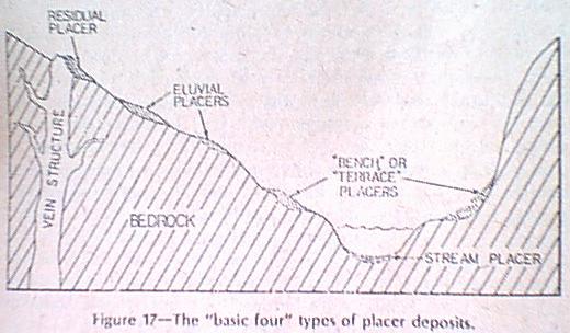
There are four principal types of placer gold deposits that will be of interest to the underwater, or for that matter, any other prospector-these are residual, alluvial, stream, and bench placers. Before we actually get into the geology of river-borne gold deposits, let’s take a look at how gold finds its way into a river system. We shall start at the outcropping of a hypothetical gold vein on the wall of a river canyon and work our way downwards until we finally come to the watercourse; this process will be explained through definitions of residual and alluvial placer deposits.
The first type of placer gold deposit will occur at the surface of the ground where a gold vein crops out. This type of placer is called a residual deposit and is formed when the original host rock (usually quartz) erodes away, leaving pure metallic gold in place at the point of the outcrop. Gold-bearing veins located in a moist climate with heavy rainfall (southern Oregon would be an outstanding example) will erode away very quickly once being exposed to the action of the surface elements, and the resulting residual placers will often extend to tens of feet in depth due to extremely deep weathering of the original vein. Such deposits were referred to as “seam diggin’s” during the old days.
The next type of placer deposit is called an alluvial placer, and is formed after gold has traveled downward as little as a few feet from the point of its residual outcrop. (The opposite of alluvial is alluvial, which signifies gold that has been carried many miles from its original source.) A good example of an alluvial placer deposit would be gold that originally cropped out at the rim of 1,000-foot-deep river canyon and has been carried by the forces of gravity and running water five hundred feet downward, with five hundred feet still remaining before it actually enters the streamflow at the bottom.
The next two types of placer deposits – bench and stream – are interrelated, and we will first discuss the deposit that will occur next along the line – this is a stream placer. Stream placers will be of greatest interest to the individual interested in gold-dredging, as this type of placer occurs at, near, or else under the surface of a river. There are many different types of stream placers, ranging from gravel bars just barely above the surface of the water to deeply buried bedrock deposits at the bottom of the river which generally hold more gold than the rest of the river environment.
A bench placer is nothing more than a stream placer that has been left high and dry by the stream that originally created it. Bench placers are created when a large land area, usually consisting of thousands of square mils, is “rejuvenated” over a period of hundreds of thousands of years and uplifted due to pressures from the earth’s interior. If the land is uplifted enough, any streams in the area will start to cut downward until they reach their new “base level,” which will be that of sea level. As a river cuts downward over a long period of time, the bed it originally occupied before the uplift will be left stranded above the new stream level. Bench placers (also known as “terrace” deposits) are often very rich in gold, only these gravels are out of reach as far as the gold-dredger is concerned. (See Figure 17, which illustrates the “basic four” placer deposits.
The factors governing the occurrence of placer gold in a river environment are many, and quite often complex. There are so many variables involved in the science of placer geology it would be virtually impossible to mention all of them, but basically, the deposition of heavy materials in a stream is based upon the speed and volume of water flow coupled with the shape and slope of the river channel. Throw in obstructions such as large boulders, bedrock outcroppings, etc., and you have a whole new ball game.
Gold is transported in a stream principally during periods of high water, such as during the yearly spring runoff. Because gold is heavy and tends to settle in cracks and crevices at the bottom of a river, the speed of a runoff current has to be very great in order for transportation to occur. An ideal situation for heavy flooding and runoff would be as follows….
The mountains in the high country where “River X” is born are covered with one to two feet of snow, and a warm, rain-bearing storm moves in. Heavy rain starts to fall – one inch, two inches, five, ten – and in a matter of hours River X starts to rise from its banks with extreme rapidity. But River X is not merely rising from the heavy rains – the warm rains, as they fall on the shallow snowpack, turn that snow into water which also goes into the river. (It is a known fact that heavy rains falling on a shallow snowpack will melt it rapidly, whereas a deeper layer of snow will often absorb large amounts of rainfall.)
It has been 12 hours since the storm front moved in, and River X is raging like the mighty Mississippi during one of her frequent fits of rage. If you could observe Rive X at this time, you could study firsthand the conditions that lead to the deposition of placer gold. You would see a river that is flowing a filthy, muddy brown from tons of suspended silt. You would see branches, twigs, and even entire trees floating downstream with the swift current. If you dared to stick your head under the surface, you would see huge boulders bouncing along the bottom of the river as if they were mere pebbles. But if you knew what to look for, you would notice other things as well. For example, in the midst of the mighty turbulence you might see areas where the swift current gives way to quiet pools. Perhaps you would see large sections of bedrock projecting into the turbulence that cause the current to swirl around in an “eddy” motion. Or what about that large boulder out in the middle of the stream – is it your imagination, or is the current really “standing still” on its downstream side?
“River X,” as I’m sure you realize, is hypothetical, yet the three streamflow characteristics just mentioned are real and may be encountered in any river or creek. These three conditions are variations of the two basic principals of placer geology: (1) Gold and other heavy materials will settle wherever a stream current slows and drops its load, or (2) wherever heavy materials encounter an obstruction which causes them to “hang up.”
One of the big factors affecting the speed of a stream current – and thereby the deposition of gold – is the degree of slope of the stream’s channel. THe slope of a stream channel (known commonly as “gradient”) may range from extremely steep to almost flat. In general, the closer you are to the headwaters of a stream the steeper the gradient will be. A steeply sloping channel with cause a river to flow very swiftly, usually gold to be carried along with little deposition. There are exceptions, of course. If there are major obstructions on the bottom of a stream channel, gold will be trapped no matter how steep the gradient (or swift the current.)
As a stream leaves its headwaters and approaches its middle range, the gradient of the channel will decrease. As the slope of a stream channels decreases the current will run considerably slower, creating conditions more favorable for the deposition of heavy materials. The slope of the channel in the headwater area may have been as great as a couple of hundred feet per mile, but it will now average around thirty or forty feet per mile. The former figure seems to be the ideal gradient for the deposition of placer gold.
The speed of the current and gradient of the stream channel also have a great deal to do with the amount of unwanted overburden that will be deposited in a river. There are variables, but for the most part a steep gradient (coupled with a swift current such as that found near the headwaters) will result in the deposition of relatively little overburden. The further downstream you go the gentler the gradient will become, causing slower currents and the deposition of more overburden. (The middle ranges of a river are the most popular with gold-dredgers, as the depth of the overburden rarely exceeds twenty feet.) If you venture further downstream towards the mouth of a river, the gradient becomes even gentler, and sometimes approaches a level plane. An example of this would be the point where a river empties into a large valley upon its emergence from mountainous terrain. The overburden at the mouth of a river often will be hundreds of feet in depth, completely beyond the reach of conventional suction dredges.
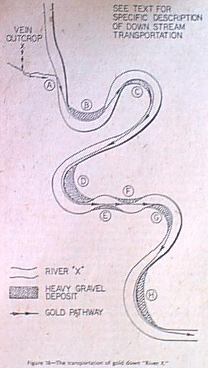
Gold is an extremely heavy metal, and when it enters a river channel, it will travel very grudgingly. Larger and heavier pieces of gold will always travel the path of least resistance in their journey downstream. Let us study this curious phenomenon as it is portrayed in Figure 18.
Let us assume that a very rich gold vein is cropping out on the side of a hill above the small gulley shown in the upper left portion of Figure 18. As the gold vein is eroded by the elements, the gold will be released from its quartz matrix and travel down the hill and enter the gulley; the gulley eventually pours its golden treasure into the drainage of River X.
The gold in our small gulley enters River X at Point A, and will rest at that location until sometime in the future when a major flood creates enough current to lift the gold from its resting place and start the downstream transportation process. When such a swift water period occurs, the gold will move from Point A across the river to the sharp inside bend at Point B. The transportation of gold in a river is simple to understand if you’ll just remember this one basic fact – “Because of its weight, gold will travel downstream in a straight line following the shortest possible path from inside bend to inside bend.” But back, now, to Fig 18.
At Point B you will notice there is a shaded area at the inside tip of the bend. This is a gravel bar, and it was formed at this location because the current of the stream slowed down when it rounded the inside bend of the curve. Whenever a stream current slows down, the river loses its power to transport the material it is carrying in suspension at times of flooding. In the case of the sharp inside bend at Point B, the current would slow considerably, causing larger boulders and heavy gravel components to drop almost immediately: one of those heavy gravel components would be gold.
After rounding the inside of the bend at Point B, our hypothetical gold nuggets would shoot across River X to the head of the next large gravel bar at Point C. Point C is actually a long, arclike curve with a gentle inside bend, and in a case such as this the gold and other heavy materials would be deposited along the entire length of the curve.
After leaving Point C our nuggets will again shoot across the river, this time over to Point D. Upon traveling around this bend our gold encounters a series of curves whose inside bends form an exact straight line. In a case such as this, gold will travel the line between inside bends as if someone got out and marked a pathway with a straightedge. Our nuggets will touch Points E, F, and G and then swinging around the latter bend and over to Point H where they will again accumulate; from here, they leave the scene once and for all. Study this illustration as well, friends, particularly the inside bends where deposits of heavy gravel material are indicated. Even though “River X” is purely fictitious, the depositional spots portrayed here are one hundred percent gunuine!
At this time i’d like to point out the gravel bars at the tips of inside bends aren’t the only places for gold to be deposited. Placer gold and heavy gravels will accumulate any place where a stream current slackens. Examples would be at the tail end of rapids where currents change from swift to placid, the upper end of deep pools which often act as “gravel dumps,” and places in a river canyon where the channel widens out upon emergence from “narrows.” When you finally get around to visiting a genuine mountain gold stream, you’ll undoubtedly spot many more depositionary areas yourself. The practice will do you good!
To search for dredging locations in areas where heavy stream materials have been deposited may sound like fun and games, but if you expect to find enough gold to make your mining efforts worthwhile, you will have to do much more than make a casual surveillance. just because you’ve found a nice, wide gravel bar or a deep, still pool doesn’t mean you’ll hit the proverbial jackpot. The gold you can expect to recover will depend upon the nature of the bedrock at the bottom of the deposit.
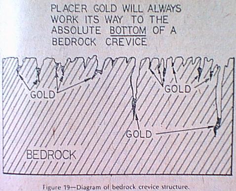
As placer gold is being carried downstream by the action of currents, the pieces of any substantial weight will gradually work their way downward through the overburden until they reach bedrock, which forms a solid, usually impenetrable obstacle to their further downward progress. Notice how I use the word usually. bedrock will act as an absolute base-level for gold’s downward motion if it is smooth and uniform, but smooth bedrock will frequently give way to stretches containing crevices extending down into the rock “basement.” Heavy pieces of gold moving downward through the overburden will find their way inot these crevices, and again start their downward movement until they have reached the absolute bottom. here they will stay, sometimes for thousands of years, unless a dredger with the proper knowledge comes along to recover them. (Figure19)
If the idea of a piece of gold staying in one crevice for thousands of years sounds somewhat “final,” that’s because it is. Once a heavy gold nugget gets lodged tightly in the bottom of a bedrock crevice, it will take a magnitude “ten” earthquake to uplift the bedrock enough so that the stream current can completely wash away the overburden and eventually wear away at the bare bedrock itself, thereby releasing the gold.
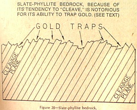
After you have located a section of river where heavy materials have been deposited, you should make a careful inspection of any visible bedrock for evidence of crevice structure. In general, bedrocks composed of slate-phyllite are most apt to develop crevices because of their “cleavage planes.” In the case of slate-phyllite, cleavage is best defined as the tendency of a rock to break off into “sheets.” When slate-phyllite form the bedrock of a river, it will frequently break off along its cleavage planes upon subjection to pounding from large boulders during times of flooding. When pieces of slate-phyllite bedrock break off, crevices that trap gold will remain between the sheets that still protrude. (Figure20)
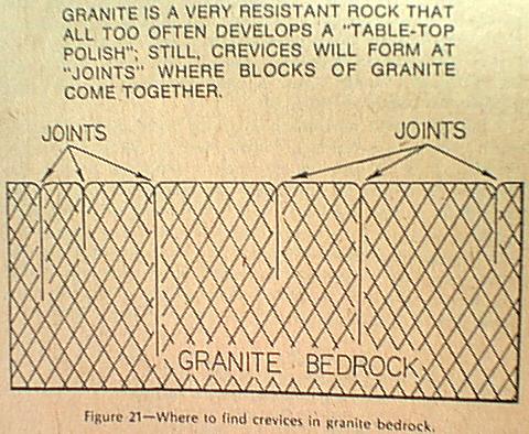
Under certain conditions granite will act as a favorable bedrock, but all too often this very resistant rock will develop a “tabletop” polish that will allow even the heaviest of gold nuggets to wash right on over. If you desire to prospect in a granite area, look for “joints” where large blocks of this material come together; there will often be crevices at such points. (Figure21)
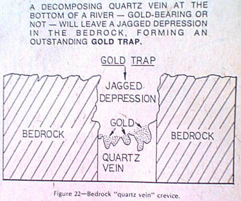
Another type of crevice that is particularly excellent for trapping gold is that which whenever a bedrock quartz vein erodes, leaving a jagged depression in the bedrock surface. (Figure22)
Bedrock quartz veins are often gold-bearing, and are the source for many gold-quartz nuggets still found in Western rivers to this date. This is a prize worth searching for!
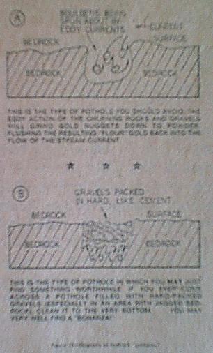
A gold diver will often become excited upon discovery of a deep pothole in the bedrock of a river, but nine times out of ten these “glory holes” will turn out to be a complete Bust. Potholes are formed when complex currents cause heavy gravels and small boulders to spin around in small eddy-like motions, scouring deep holes in the bedrock. If a piece of gold falls into such a pothole (often referred to as a “boil hole”), it will most likely be ground up by the eddy action of the gravels. The fine, powdery gold that may once have been a beautiful specimen nugget before entering the pothole will now wash out with the current and continue its journey downstream.(Figure23-A)
But there are exceptions to every rule. If you should ever locate a pothole filled with large, coarse gravels packed in hard like cement, run – don’t walk to the nearest available gold-dredge! You just might be onto one of those rare gold traps that was passed up by the original Gold Rushers back in the 1850’s. Potholes of this nature have yielded pounds of gold, particularly if they occur in jagged, pockety bedrock.(Figure23-B)
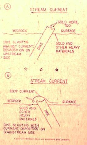
So far i’ve talked about crevices and potholes that extend down into the bedrock, but there are also gold traps that protrude from the bedrock surface. A good example of this would be a “dike” of hard, resistant rock material that originally intruded its way up into softer, surrounding rock that eventually became the bottom of a river canyon. Over a period of thousands of years, the pounding of boulders on the bottom of the stream channel wore away much of the soft country rock leaving the harder dikes protruding from the bedrock. (See Figures 24-A and B)
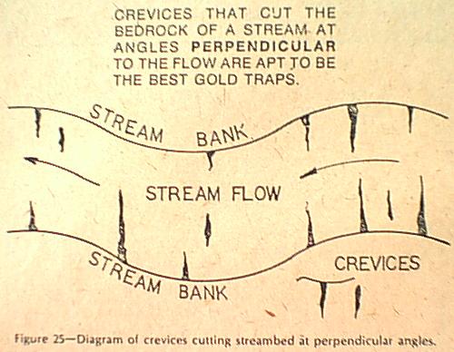
If the dike has a good slant against the direction of the stream current, heavy materials will catch under the resulting overhang on the upstream side of the dike(24-A); when the dike slants downstream; the resulting overhang will often act as a natural riffle and cause an eddy current to form. The crevice systems in a bedrock are most apt to catch and hold placer gold when they cut at angles perpendicular to the flow of the stream.(Figure 25)
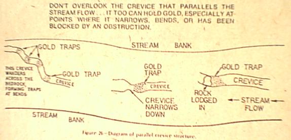
The closer the angle approaches 90 degrees, the better. If you can locate slate-phyllite bedrock, for example, with cleavage planes that slant against the flow of the current while cutting the stream at 90 degrees, you have located the “gold divers dream.” but at the same time don’t overlook long, narrow crevices that run parallel with the stream flow – they, too, can hold bonanzas. The width of the parallel crevices will usually vary, going from narrow to wide, wide to narrow, etc. The point where the crevice narrows down from a wide portion is an exceedingly good gold trap that is often overlooked buy the uninitiated. The same will hold true for crevices that wander across at irregular angles, such as forty-five degrees.(Figure 26)
It is a common misconception among many beginning gold-dredgers that if they vacuum their way down to bedrock and lay it bare, they can pick up the nuggets with their fingers. Unfortunately, this is not the case. True, there will often be small flakes of gold occurring on the bedrock surface, but larger nuggets will almost always be lodged tightly into the crevice structure. The only way of recovering all the gold from a given section of bedrock is to pry the crevices open and scrape them clean. (The recovery of gold from an underwater crevice is a fine art, and there is actually much more to it than I’ve mentioned here).
Rivers that flow through mountainous terrain rarely, if ever, have a free and easy pathway to follow on their long and eventual journey to a valley or sea. From star to finish, the channel of a mountain steam will resist the smooth flow of water by presenting one obstacle after another. An op-the-spot inspection of a mountain river will reveal such features as monstrous boulders, sections of bedrock jutting into the stream as if to choke off its life flow, perhaps even waterfalls that plunge dozens of feet into dark, mysterious pools below. In spite of its chaotic appearance, everything is in perfect order in a mountain streamflow environment, and we will have to study it for what it is – obstructions and all.
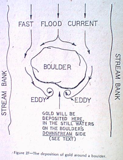
The most common obtruction to prevent the smooth flow of water in a mountainous river channel is the common boulder. Boulders come in all shapes and sizes, ranging from minor nuisances a foot or two across all the way up to gigantic masses of rock the size of a bungalow. Boulders that fall between these two extremes deserve the attention of the underwater prospector, because they will often concentrate huge amounts of gold near their bases – particularly if they rest on bedrock. Strange things happen when the gold-carrying flood current of a river encounters a large boulder. lets study Figure 27 to get the story.
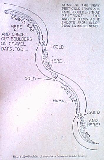
In this hypothetical situation we have a large, somewhat rounded boulder in the middle of a stream that is at the height of its yearly flood stage. The current is flowing at a frightening clip, and we surely wouldn’t want to fall in at this time! As the swift current slams into the upstream side of the boulder, it is deflected around the outside perimeter due to the roundness of the rock mass. When the current “rounds the corner” and approaches the downstream side of the boulder, it will start to circulate in an eddy motion around the rear of the boulder and practically stand still. If the stream current happens to be transporting gold, the heavy yellow metal will be carried along the perimeter of the boulder to eventually settle in the still waters on the downstream side. It is possible for gold to be trapped on the upstream side of a boulder, but usually there will have to be a substantial fissure in the face of the rock mass to catch the gold as it is impaled against the boulder by the current. Boulders often have yielded large amounts of gold to the dredger who diligently cleans them down to the base, but which boulders, specifically, are most apt to hold the golden treasure? The answer is simple – look for large boulders in mid-stream that obstruct the flow of current as it travels from inside bend to inside bend. (Figure 28)
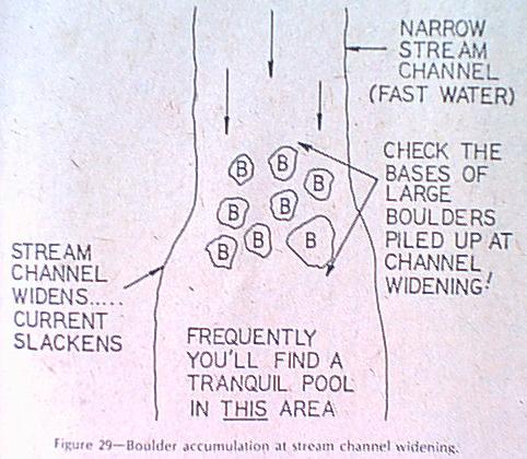
As we already know, gold tends to travel from the tip of one inside bend to the other, but if there is an obstruction in the current flow as it shoots between bends (namely a boulder), some of the heavier gold will never make it to the inside of the next bend. Always keep an eye out for this type of condition, and check the downstream side of any large boulders that appear to be in the correct position. One of the best of all possible spots for the deposition of placer gold will be an accumulation of large boulders at a point where a stream channel widens.
In the upper part of Figure 29, the river is traveling through an extremely narrow gap , a channel condition which causes currents to flow at tremendous speeds. The water is so swift it even carries large boulders which don’t get a chance to settle in the narrows. As soon as the stream emerges from the narrows, the large boulders will drop immediately at the beginning of the widening. If you really want to find a potential “super-spot”, check the gravel on the downstream sides of boulders such as this.
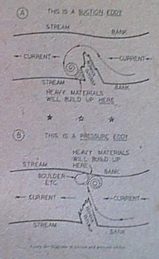
Boulders are not the only objects to obstruct stream channels to the advantage of the gold-dredger. Another very favorable location will be an area where a large section of bedrock protrudes out into a stream, causing an eddy current to circulate around the outcropping. Whenever a chunk of bedrock sticks out into a river on an angle slanting with the current, an eddy will circulate on the downstream side of the obstruction causing a buildup of heavy material. This type of eddy is called a suction eddy. (Figure 30-A)
If the current flowing across the face of a downstream-slanted bedrock outcrop is fierce enough, it will sometimes shoot across the stream and cause an eddy to circulate around an object on the opposite bank; this condition is known as a pressure eddy. (Figure30-B) The nature of bedrock outcroppings that protrude into a channel against the flow of the current is tricky, and one would almost have to see the river in question at the height of its flood stage to get an idea of where the eddy currents will form. An outcropping that protrudes far out into the current (as shown in Figure 31-A) will most likely catch the current on the outermost projection of the bedrock and cause an eddy to swirl in toward the shore. The spot indicated by the “X” would be a possible depositionary area. If the outcropping is only a minor projection into the flow of the current (Figure 31-B), any number of things can happen. The stream current can bypass the projection entirely, it can partially flow against the outcrop with the major part running out toward the middle of the channel, or the major portion can flwo against the outcrop and circulate in a “half-eddy,” flushing the material in suspension back out into the middle of the stream. Now you can understand why I say an on-the-spot inspection of an upstream-slanted bedrock outcropping is a virtual necessity!
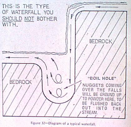
Every so often you hear stories about how a gold-dredger recovered a fabulous amount of gold from the base of a waterfall. Before you start getting “waterfall happy,” let’s set the record straight once and for all. The average waterfall – -if it is of any substantial height – Creates downward currents of extreme ferocity and will tend to carve a deep, turbulent biol hole right at it’s base. (See Figure 32)
Nine times out of ten, any gold coming over the falls will drop into this boil hole to be ground up into flakes that will soon wash out with the current. So in this sense, anyway, waterfalls should be avoided when your out looking for dredging spots. But as we have seen many times during the course of this text there are exceptions to every rule, and in this case the exception is a humdinger.
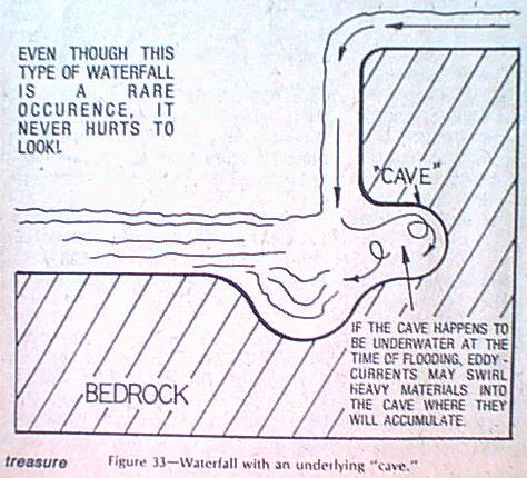
Every so often a waterfall will flow over a layer of extremely hard, weather-resistant rock that overlays softer rock beneath. As water goes over the falls, it will cause the underlying softer rock to erode back under the upper layer of harder material. This will create a kind if “cave” under the falls. (Figure 33)
If the cave happens to be below the water line at the time of flooding, a powerful eddy current may develop which will occasionally (and I do emphasize the word occasionally) cause heavy materials to swirl back into the cave and become entrapped. There have been a number of fabulously rich dredging finds taken from such locations, but you could count the grand total on the fingers of one hand. Even so, it will pay you to take no chances….investigate!
Good luck and happy Hunting!

By far one of the most informative reads pertaining to placer finds in a river/stream. Thanks for the share!